Blog
F-5 Sector Boundaries and Surrounding Margalla Hubs
Real Estate Analyst
13 min read
Short Answer:
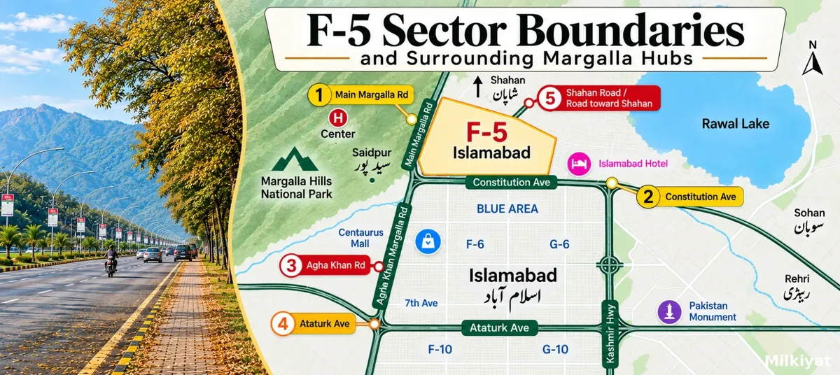
F-5 is a small, mostly institutional sector in Islamabad's Zone I, bounded by Khayaban-e-Iqbal (Margalla Road) to the north, Ataturk Avenue to the west, Jinnah Avenue and the Blue Area to the south, and Constitution Avenue and the Red Zone to the east. The F-5 Islamabad F-6 boundary is Ataturk Avenue, a single six-lane road is all that separates the two sectors. F-5 does not touch F-7 at any point; F-6 sits between them. Its northern edge opens directly onto the Margalla Hills, and Trail 5 begins from Margalla Road inside F-5 itself.
In most Islamabad sectors, the boundary is an administrative detail. In F-5 it is the entire investment case.
F-5 is one of the capital's original sectors, laid out in the 1960s alongside F-6, F-7, G-5, G-6 and G-7. It is small, it is almost fully institutional rather than residential, and it is completely enclosed by four of the most significant roads in Pakistan. On one side is a national park. On another is the seat of federal government. On a third is the country's most expensive commercial strip. On the fourth is the most established residential sector in Islamabad.
There is no new land in F-5 and there will never be any. What trades here is a fixed stock of plots and buildings whose value is set almost entirely by which edge they sit against. A buyer who understands the four boundaries understands F-5 better than a buyer who has read a dozen price listings.
This guide maps each edge, explains what lies immediately across it, and sets out what each frontier means in practice for anyone buying, leasing or building in the sector. It sits alongside our complete F-5 Islamabad commuter guide, which covers how you actually move in and out of the sector once you are there.
Real Estate Analyst
13 min read
Short Answer:
F-5 is a small, mostly institutional sector in Islamabad's Zone I, bounded by Khayaban-e-Iqbal (Margalla Road) to the north, Ataturk Avenue to the west, Jinnah Avenue and the Blue Area to the south, and Constitution Avenue and the Red Zone to the east. The F-5 Islamabad F-6 boundary is Ataturk Avenue, a single six-lane road is all that separates the two sectors. F-5 does not touch F-7 at any point; F-6 sits between them. Its northern edge opens directly onto the Margalla Hills, and Trail 5 begins from Margalla Road inside F-5 itself.
In most Islamabad sectors, the boundary is an administrative detail. In F-5 it is the entire investment case.
F-5 is one of the capital's original sectors, laid out in the 1960s alongside F-6, F-7, G-5, G-6 and G-7. It is small, it is almost fully institutional rather than residential, and it is completely enclosed by four of the most significant roads in Pakistan. On one side is a national park. On another is the seat of federal government. On a third is the country's most expensive commercial strip. On the fourth is the most established residential sector in Islamabad.
There is no new land in F-5 and there will never be any. What trades here is a fixed stock of plots and buildings whose value is set almost entirely by which edge they sit against. A buyer who understands the four boundaries understands F-5 better than a buyer who has read a dozen price listings.
This guide maps each edge, explains what lies immediately across it, and sets out what each frontier means in practice for anyone buying, leasing or building in the sector. It sits alongside our complete F-5 Islamabad commuter guide, which covers how you actually move in and out of the sector once you are there.
The northern boundary of F-5 is Khayaban-e-Iqbal, universally called Margalla Road. Beyond it there is no sector at all — the land rises into the foothills and becomes Margalla Hills National Park, which falls under Zone III of the Islamabad master plan and is closed to sectoral development.
This is the boundary that cannot change. Every other edge of F-5 abuts land someone could theoretically redevelop. The northern edge abuts protected hillside. For a buyer, that permanence is the single most valuable feature of a north-facing property in the sector: the view is not a marketing claim, it is a planning outcome.
It also has practical consequences. Margalla Road is the sector's fastest artery, running east–west along the foothills and connecting F-5 to F-6, F-7, F-8 and eventually the western sectors without a single traffic signal in between. Property along this edge gains that access but also absorbs the noise of it.
The F-5 Islamabad F-6 boundary is Ataturk Avenue, running north–south from Margalla Road down towards Jinnah Avenue. On the western side sits F-6/3 in the north and F-6/4 in the south; on the eastern side sits F-5.
This is the most consequential of the four boundaries for residential buyers, because it is the only edge where F-5 meets a genuinely residential sector. F-6 is old, leafy, embassy-heavy and expensive, and its sub-market pricing bleeds across Ataturk Avenue into F-5's residential pockets. Kohsar Market in F-6/3 is the closest full-service commercial cluster to most of F-5, and it is a short drive rather than a journey.
Two details are worth holding on to. First, Agha Khan Road crosses Ataturk Avenue and continues into F-5, which is why addresses on that road appear in both sectors and why buyers occasionally believe a property is in F-6 when it is not. Second, the F-6 side of the avenue is fully built out with private residential plots, while the F-5 side is dominated by institutional buildings, so a plot on the F-5 edge of Ataturk Avenue is often surrounded by offices rather than homes. Verify the land use on the CDA sector plan before you assume a residential neighbour.
F-5's southern edge runs along Jinnah Avenue, the axis of the Blue Area. This is where the sector meets Islamabad's commercial core: banking headquarters, corporate towers, the ministries' commercial annexes and the densest office employment in the capital.
The F-5 Islamabad G-6 boundary is best described honestly, because most online guides get it wrong. F-5 and G-6 do not share a straight edge in the way F-5 and F-6 do. Islamabad's grid runs with letters increasing north to south and numbers increasing east to west, which places G-5 directly south of F-5 and G-6 south of F-6. What actually separates F-5 from G-6 is the Jinnah Avenue corridor and the Blue Area strip laid along it, with the G-6 sub-sectors beginning immediately beyond.
In daily life the distinction barely registers. Aabpara and Melody in G-6 are the everyday markets that F-5 residents and office workers use for groceries, hardware, tailoring and repairs, because F-5 itself has no markaz of its own. Aabpara doubles as the sector's informal transport hub, since F-5 has no bus stop of its own inside its residential streets, a gap covered in detail in our F-5 public transportation and metro guide. The relationship is real; the shared border is not. Anyone quoting "F-5 and G-6 are adjacent sectors" as a selling point is describing convenience, not cartography.
The eastern boundary is Constitution Avenue, and across it lies the Red Zone: Parliament House, the Supreme Court, the Presidency, the Prime Minister's Office, the Cabinet Block and the Diplomatic Enclave, all within sector G-5.
This is F-5's defining edge and its most double-sided one. On the upside, no other residential-capable sector in Islamabad puts a buyer within walking distance of the federal government. That proximity is why provincial guest houses such as Balochistan House, senior officials' residences and a dense cluster of federal offices are located in F-5/2 rather than anywhere else.
On the downside, Red Zone security is not theoretical. Constitution Avenue and its approach roads are closed to general traffic during protests, state visits, parliamentary sessions of consequence and VIP movement. Closures can last hours and occasionally days, and they affect the F-5 side of the line as well as the G-5 side. Any buyer weighing an east-facing property in F-5 should treat episodic access restriction as a permanent feature of the address rather than an occasional inconvenience, and should test the alternative routes out of the sector before committing.
F-5 is split into two sub-sectors, F-5/1 and F-5/2, separated by Agha Khan Road running through the middle.
F-5/1 occupies the northern portion and carries much of the sector's institutional weight — the Evacuee Trust Complex, which houses one of Islamabad's two original Software Technology Parks and a long roster of IT firms, call centres and federal offices, sits here on Agha Khan Road, as does the Federal Public Service Commission and the Islamabad Marriott. Older addresses in this part of the sector still carry the "Shalimar" name from the original 1960s planning nomenclature, which is why some legal documents and hotel addresses read differently from the modern sector code.
F-5/2 occupies the southern and eastern portion, closer to Constitution Avenue, and is where the provincial houses and much of the senior official housing is concentrated. The Pakistan Television headquarters and the Evacuee Trust complex give the sector a working-day population far larger than its residential population.
Two absences shape the sector's character. F-5 has no markaz, unlike F-6, F-7 or F-8, it was never given a central commercial market, and it has no school inside its boundaries. Residents rely on F-6, G-6 and the Blue Area for both. That dependency is exactly why the boundary roads matter so much here: in F-5, ordinary daily life happens across the line.
Search demand for the F-5 Islamabad F-7 boundary is significant, and the honest answer is that there isn't one.
Islamabad's sector numbers increase from east to west. F-5 sits furthest east in the F series, F-6 comes next, then F-7, then F-8. F-6 occupies the full width between F-5 and F-7, which means the two sectors are separated by roughly two kilometres of built-up residential land and two boundary roads, not one shared edge.
The confusion is understandable. F-5, F-6 and F-7 all sit on the same Margalla Road frontage, share the same foothill setting, and are marketed together as Islamabad's premium northern belt. A property advertised as being "between F-5 and F-7" is describing F-6. If you are shown a plot on that basis, ask for the sector code on the CDA allotment letter and confirm it, rather than accepting a corridor description.
For anyone building a mental map of the area, our Islamabad infrastructure and development guide covers how the wider road network ties these sectors together, and the distance and area converter is useful for translating marla, kanal and square-foot figures across listings that use different units.
The northern boundary is the one that turns F-5 from a government address into a lifestyle one. The recreational assets sitting immediately beyond Margalla Road are, in order of proximity:
Trail 5. According to the Capital Development Authority's own adventure and trails listing, Trail 5 begins from Margalla Road in sector F-5 and climbs to the top of Pir Sohawa Road, a route of roughly two and a half to three and a half hours. It runs parallel to Trail 3 for part of its length, and the two are linked by Trail 4. This makes F-5 one of the very few Islamabad sectors with a signposted national park trailhead on its own boundary road.
Trail 3. The oldest and busiest route in the network, starting from Margalla Road at the F-6 end, near the Margalla Road–Ataturk Avenue junction. From most of F-5 it is a five-minute drive along the northern boundary.
Daman-e-Koh and Pir Sohawa. The two principal viewpoints, reached by car along Pir Sohawa Road, which climbs from the foothills west of the sector. Both are roughly a fifteen to twenty-minute drive from F-5 depending on the entry point and weekend traffic.
Saidpur Village. The restored Mughal-era village and heritage site sits just off Margalla Road opposite the F-6/F-7 stretch, a short westward run along the sector's northern edge.
Marghazar Zoo and the foothill parks. The green belt strung along the northern side of Margalla Road, including the cricket grounds and children's parks facing the F-6 sub-sectors, is continuous public land from F-5 westwards.
The point for a buyer is not the list itself but its geometry. All of it is reached by turning north onto a single road that forms the sector's own boundary. There is no cross-city commute involved, no expressway, no interchange. For a luxury purchaser weighing F-5 against newer high-end schemes on the city's periphery, that is the trade being made: a smaller, older, institutionally constrained sector in exchange for the shortest distance in Islamabad between a front door and a national park.
Supply is fixed and mostly institutional. F-5's residential stock is small and much of the sector is allocated to federal and provincial use. Genuine open-market residential transactions are infrequent, which makes pricing thin and comparables scarce. Expect to negotiate against limited evidence.
Land use is the first thing to verify, not the last. Because institutional and residential plots sit side by side across F-5, confirming the approved land use on the CDA sector plan matters more here than in a uniformly residential sector. The Capital Development Authority remains the sole competent authority for sector plans, allotment records and transfers in Zone I.
Height and construction near the hills are constrained. Proximity to Margalla Hills National Park brings environmental and height sensitivities that do not apply in the southern sectors. Confirm what your plot's building plan will actually permit before you price the property on its view.
Access risk is real on the eastern edge. Red Zone closures are the honest counterweight to Red Zone proximity, and they should be priced in rather than discovered later. Metro and feeder options along the southern and western boundaries stay open when the eastern approaches are sealed, which is why the F-5 transit and metro options matter even to buyers who intend to drive.
Commercial dependency runs across the boundary. No markaz, no school. Everything routine happens in F-6, G-6 or the Blue Area, so evaluate the boundary crossings you will use daily, not just the plot itself.
For buyers comparing this against the rest of the capital, our guides on CDA-approved housing societies in Islamabad and house versus plot investment returns in Islamabad set out the alternatives, while our CDA and RDA jurisdiction comparison explains why an address inside CDA's Zone I carries a different risk profile from one in a private scheme.
1. What road forms the F-5 Islamabad F-6 boundary?
Ataturk Avenue. It runs north–south between the two sectors, from Margalla Road down towards Jinnah Avenue, with F-6/3 and F-6/4 on the western side and F-5 on the eastern side.
2. Does F-5 share a border with F-7?
No. F-6 sits entirely between F-5 and F-7. Any listing that describes a property as lying "between F-5 and F-7" is describing a location in F-6.
3. Where is the F-5 Islamabad G-6 boundary?
There is no shared straight edge. F-5's southern frontier is Jinnah Avenue and the Blue Area commercial strip, with G-5 directly to the south and the G-6 sub-sectors beginning beyond the Blue Area. In practice, Aabpara and Melody in G-6 serve as F-5's nearest everyday markets.
4. Which Margalla trail starts closest to F-5?
Trail 5. The Capital Development Authority lists its starting point as Margalla Road in sector F-5, with Trail 3 beginning a short distance west along the same road at the F-6 end.
5. Is F-5 part of the Red Zone?
F-5 sits immediately west of it. The Red Zone proper covers the Constitution Avenue belt in G-5, but F-5's eastern edge is affected by the same security closures during protests, state visits and VIP movement.
6. Why does F-5 have no markaz?
It was planned as a predominantly institutional and government sector rather than a self-contained residential one. Residents and office workers use F-6's Kohsar Market, the Blue Area and G-6's Aabpara and Melody markets instead.
Written for Milkiyat. Browse the full library of Islamabad and Punjab property guides at milkiyat.com/guides.
The northern boundary of F-5 is Khayaban-e-Iqbal, universally called Margalla Road. Beyond it there is no sector at all — the land rises into the foothills and becomes Margalla Hills National Park, which falls under Zone III of the Islamabad master plan and is closed to sectoral development.
This is the boundary that cannot change. Every other edge of F-5 abuts land someone could theoretically redevelop. The northern edge abuts protected hillside. For a buyer, that permanence is the single most valuable feature of a north-facing property in the sector: the view is not a marketing claim, it is a planning outcome.
It also has practical consequences. Margalla Road is the sector's fastest artery, running east–west along the foothills and connecting F-5 to F-6, F-7, F-8 and eventually the western sectors without a single traffic signal in between. Property along this edge gains that access but also absorbs the noise of it.
The F-5 Islamabad F-6 boundary is Ataturk Avenue, running north–south from Margalla Road down towards Jinnah Avenue. On the western side sits F-6/3 in the north and F-6/4 in the south; on the eastern side sits F-5.
This is the most consequential of the four boundaries for residential buyers, because it is the only edge where F-5 meets a genuinely residential sector. F-6 is old, leafy, embassy-heavy and expensive, and its sub-market pricing bleeds across Ataturk Avenue into F-5's residential pockets. Kohsar Market in F-6/3 is the closest full-service commercial cluster to most of F-5, and it is a short drive rather than a journey.
Two details are worth holding on to. First, Agha Khan Road crosses Ataturk Avenue and continues into F-5, which is why addresses on that road appear in both sectors and why buyers occasionally believe a property is in F-6 when it is not. Second, the F-6 side of the avenue is fully built out with private residential plots, while the F-5 side is dominated by institutional buildings, so a plot on the F-5 edge of Ataturk Avenue is often surrounded by offices rather than homes. Verify the land use on the CDA sector plan before you assume a residential neighbour.
F-5's southern edge runs along Jinnah Avenue, the axis of the Blue Area. This is where the sector meets Islamabad's commercial core: banking headquarters, corporate towers, the ministries' commercial annexes and the densest office employment in the capital.
The F-5 Islamabad G-6 boundary is best described honestly, because most online guides get it wrong. F-5 and G-6 do not share a straight edge in the way F-5 and F-6 do. Islamabad's grid runs with letters increasing north to south and numbers increasing east to west, which places G-5 directly south of F-5 and G-6 south of F-6. What actually separates F-5 from G-6 is the Jinnah Avenue corridor and the Blue Area strip laid along it, with the G-6 sub-sectors beginning immediately beyond.
In daily life the distinction barely registers. Aabpara and Melody in G-6 are the everyday markets that F-5 residents and office workers use for groceries, hardware, tailoring and repairs, because F-5 itself has no markaz of its own. Aabpara doubles as the sector's informal transport hub, since F-5 has no bus stop of its own inside its residential streets, a gap covered in detail in our F-5 public transportation and metro guide. The relationship is real; the shared border is not. Anyone quoting "F-5 and G-6 are adjacent sectors" as a selling point is describing convenience, not cartography.
The eastern boundary is Constitution Avenue, and across it lies the Red Zone: Parliament House, the Supreme Court, the Presidency, the Prime Minister's Office, the Cabinet Block and the Diplomatic Enclave, all within sector G-5.
This is F-5's defining edge and its most double-sided one. On the upside, no other residential-capable sector in Islamabad puts a buyer within walking distance of the federal government. That proximity is why provincial guest houses such as Balochistan House, senior officials' residences and a dense cluster of federal offices are located in F-5/2 rather than anywhere else.
On the downside, Red Zone security is not theoretical. Constitution Avenue and its approach roads are closed to general traffic during protests, state visits, parliamentary sessions of consequence and VIP movement. Closures can last hours and occasionally days, and they affect the F-5 side of the line as well as the G-5 side. Any buyer weighing an east-facing property in F-5 should treat episodic access restriction as a permanent feature of the address rather than an occasional inconvenience, and should test the alternative routes out of the sector before committing.
F-5 is split into two sub-sectors, F-5/1 and F-5/2, separated by Agha Khan Road running through the middle.
F-5/1 occupies the northern portion and carries much of the sector's institutional weight — the Evacuee Trust Complex, which houses one of Islamabad's two original Software Technology Parks and a long roster of IT firms, call centres and federal offices, sits here on Agha Khan Road, as does the Federal Public Service Commission and the Islamabad Marriott. Older addresses in this part of the sector still carry the "Shalimar" name from the original 1960s planning nomenclature, which is why some legal documents and hotel addresses read differently from the modern sector code.
F-5/2 occupies the southern and eastern portion, closer to Constitution Avenue, and is where the provincial houses and much of the senior official housing is concentrated. The Pakistan Television headquarters and the Evacuee Trust complex give the sector a working-day population far larger than its residential population.
Two absences shape the sector's character. F-5 has no markaz, unlike F-6, F-7 or F-8, it was never given a central commercial market, and it has no school inside its boundaries. Residents rely on F-6, G-6 and the Blue Area for both. That dependency is exactly why the boundary roads matter so much here: in F-5, ordinary daily life happens across the line.
Search demand for the F-5 Islamabad F-7 boundary is significant, and the honest answer is that there isn't one.
Islamabad's sector numbers increase from east to west. F-5 sits furthest east in the F series, F-6 comes next, then F-7, then F-8. F-6 occupies the full width between F-5 and F-7, which means the two sectors are separated by roughly two kilometres of built-up residential land and two boundary roads, not one shared edge.
The confusion is understandable. F-5, F-6 and F-7 all sit on the same Margalla Road frontage, share the same foothill setting, and are marketed together as Islamabad's premium northern belt. A property advertised as being "between F-5 and F-7" is describing F-6. If you are shown a plot on that basis, ask for the sector code on the CDA allotment letter and confirm it, rather than accepting a corridor description.
For anyone building a mental map of the area, our Islamabad infrastructure and development guide covers how the wider road network ties these sectors together, and the distance and area converter is useful for translating marla, kanal and square-foot figures across listings that use different units.
The northern boundary is the one that turns F-5 from a government address into a lifestyle one. The recreational assets sitting immediately beyond Margalla Road are, in order of proximity:
Trail 5. According to the Capital Development Authority's own adventure and trails listing, Trail 5 begins from Margalla Road in sector F-5 and climbs to the top of Pir Sohawa Road, a route of roughly two and a half to three and a half hours. It runs parallel to Trail 3 for part of its length, and the two are linked by Trail 4. This makes F-5 one of the very few Islamabad sectors with a signposted national park trailhead on its own boundary road.
Trail 3. The oldest and busiest route in the network, starting from Margalla Road at the F-6 end, near the Margalla Road–Ataturk Avenue junction. From most of F-5 it is a five-minute drive along the northern boundary.
Daman-e-Koh and Pir Sohawa. The two principal viewpoints, reached by car along Pir Sohawa Road, which climbs from the foothills west of the sector. Both are roughly a fifteen to twenty-minute drive from F-5 depending on the entry point and weekend traffic.
Saidpur Village. The restored Mughal-era village and heritage site sits just off Margalla Road opposite the F-6/F-7 stretch, a short westward run along the sector's northern edge.
Marghazar Zoo and the foothill parks. The green belt strung along the northern side of Margalla Road, including the cricket grounds and children's parks facing the F-6 sub-sectors, is continuous public land from F-5 westwards.
The point for a buyer is not the list itself but its geometry. All of it is reached by turning north onto a single road that forms the sector's own boundary. There is no cross-city commute involved, no expressway, no interchange. For a luxury purchaser weighing F-5 against newer high-end schemes on the city's periphery, that is the trade being made: a smaller, older, institutionally constrained sector in exchange for the shortest distance in Islamabad between a front door and a national park.
Supply is fixed and mostly institutional. F-5's residential stock is small and much of the sector is allocated to federal and provincial use. Genuine open-market residential transactions are infrequent, which makes pricing thin and comparables scarce. Expect to negotiate against limited evidence.
Land use is the first thing to verify, not the last. Because institutional and residential plots sit side by side across F-5, confirming the approved land use on the CDA sector plan matters more here than in a uniformly residential sector. The Capital Development Authority remains the sole competent authority for sector plans, allotment records and transfers in Zone I.
Height and construction near the hills are constrained. Proximity to Margalla Hills National Park brings environmental and height sensitivities that do not apply in the southern sectors. Confirm what your plot's building plan will actually permit before you price the property on its view.
Access risk is real on the eastern edge. Red Zone closures are the honest counterweight to Red Zone proximity, and they should be priced in rather than discovered later. Metro and feeder options along the southern and western boundaries stay open when the eastern approaches are sealed, which is why the F-5 transit and metro options matter even to buyers who intend to drive.
Commercial dependency runs across the boundary. No markaz, no school. Everything routine happens in F-6, G-6 or the Blue Area, so evaluate the boundary crossings you will use daily, not just the plot itself.
For buyers comparing this against the rest of the capital, our guides on CDA-approved housing societies in Islamabad and house versus plot investment returns in Islamabad set out the alternatives, while our CDA and RDA jurisdiction comparison explains why an address inside CDA's Zone I carries a different risk profile from one in a private scheme.
1. What road forms the F-5 Islamabad F-6 boundary?
Ataturk Avenue. It runs north–south between the two sectors, from Margalla Road down towards Jinnah Avenue, with F-6/3 and F-6/4 on the western side and F-5 on the eastern side.
2. Does F-5 share a border with F-7?
No. F-6 sits entirely between F-5 and F-7. Any listing that describes a property as lying "between F-5 and F-7" is describing a location in F-6.
3. Where is the F-5 Islamabad G-6 boundary?
There is no shared straight edge. F-5's southern frontier is Jinnah Avenue and the Blue Area commercial strip, with G-5 directly to the south and the G-6 sub-sectors beginning beyond the Blue Area. In practice, Aabpara and Melody in G-6 serve as F-5's nearest everyday markets.
4. Which Margalla trail starts closest to F-5?
Trail 5. The Capital Development Authority lists its starting point as Margalla Road in sector F-5, with Trail 3 beginning a short distance west along the same road at the F-6 end.
5. Is F-5 part of the Red Zone?
F-5 sits immediately west of it. The Red Zone proper covers the Constitution Avenue belt in G-5, but F-5's eastern edge is affected by the same security closures during protests, state visits and VIP movement.
6. Why does F-5 have no markaz?
It was planned as a predominantly institutional and government sector rather than a self-contained residential one. Residents and office workers use F-6's Kohsar Market, the Blue Area and G-6's Aabpara and Melody markets instead.
Written for Milkiyat. Browse the full library of Islamabad and Punjab property guides at milkiyat.com/guides.
F-5 has no metro station of its own, but the Red Line terminus at Pak Secretariat sits on its southern edge. Here is every station, feeder route, fare and timing that matters for commuting into and out of the sector.
Compare Bahria Town Phase 7 and Phase 8 Rawalpindi rental yields, tenant demand, mature sectors, expanding areas and the risks shaping landlord returns.
Airport Green Garden vs Airport Enclave: Compare approval records, NOC status, title checks and key risks before buying property near Islamabad Airport.
Compare PWD Housing Society and Soan Garden, exploring Islamabad Highway access, commuting, commercial activity, residential appeal and location advantages for buyers.
F-5 has no metro station of its own, but the Red Line terminus at Pak Secretariat sits on its southern edge. Here is every station, feeder route, fare and timing that matters for commuting into and out of the sector.
Compare Bahria Town Phase 7 and Phase 8 Rawalpindi rental yields, tenant demand, mature sectors, expanding areas and the risks shaping landlord returns.
Airport Green Garden vs Airport Enclave: Compare approval records, NOC status, title checks and key risks before buying property near Islamabad Airport.
Compare PWD Housing Society and Soan Garden, exploring Islamabad Highway access, commuting, commercial activity, residential appeal and location advantages for buyers.
