News
Islamabad Master Plan Violations Linked to Worsening Urban Flooding

By Mariam Khan
Real Estate Analyst
5 min read
ShareWhatsApp
News
By Mariam Khan
Real Estate Analyst
5 min read
News
By Mariam Khan
Real Estate Analyst
5 min read
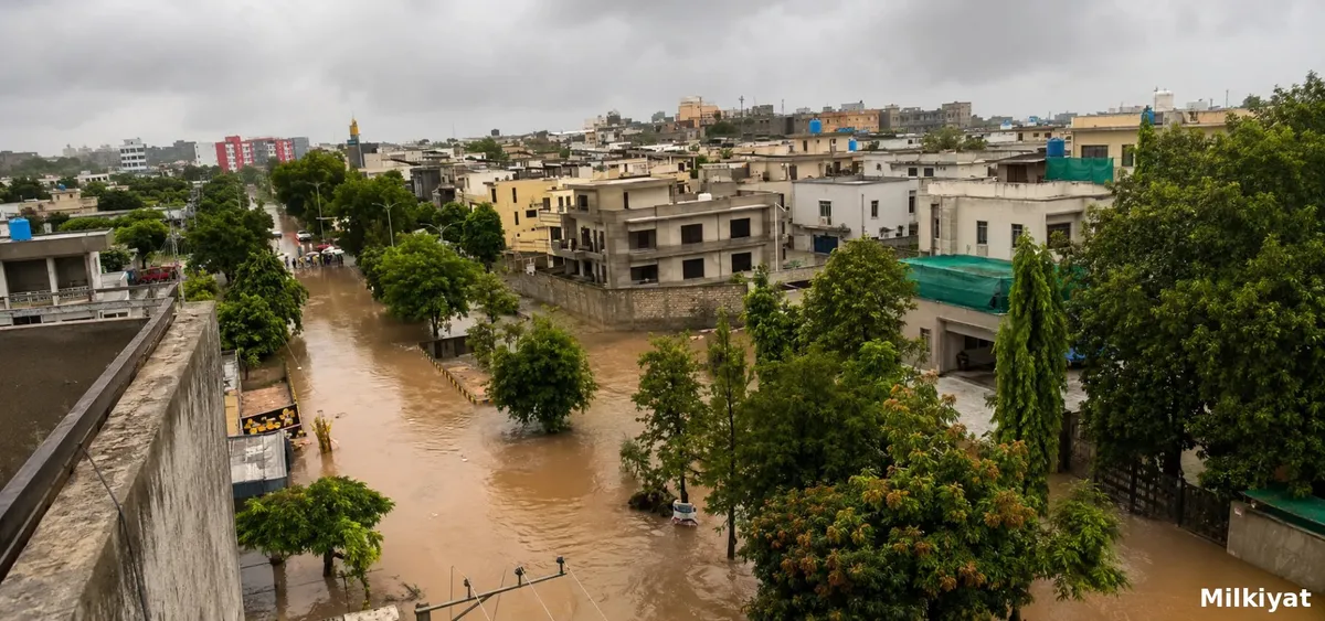
Violations of Islamabad's master plan and encroachment on natural nullahs are contributing directly to flash flooding in Sector E-11, Park Road, and Ghauri Town, with CDA now planning a new E-11 nullah, four check dams, and removal of constructions obstructing waterways as a response.
E-11's flood risk is not a matter of speculation. Layout plan records show a drainage channel in the sector was approved with a width of 40 feet in 2007, before a housing society operating in the area later had its layout plan revised in 2012, reducing the same nullah's width to just 18 feet, with a cover built over it. This narrowing was formally processed and approved through CDA's own planning channels at the time, meaning the reduction in drainage capacity that is now contributing to flooding was not an unauthorised act carried out in secret, but a change that passed through the authority's own official review.
In the broader pattern affecting E-11, a housing society originally obtained layout plan approval from CDA in 2010 to 2012, and on the basis of that layout plan alone began selling plots and allowing construction to proceed, before ever obtaining the No Objection Certificate legally required before development could begin. CDA eventually revoked approval of that layout plan, but only after substantial construction had already taken place along the nullah's banks.
A particularly significant gap in Islamabad's flood defences traces back to a check dam CDA had planned for construction in the area, intended specifically to help manage stormwater from the Margalla Hills catchment before it reached the more densely populated parts of the sector below. CDA never acquired the land required to actually build this dam, and the proposed site has since become part of privately developed housing societies, meaning the protective infrastructure that was meant to exist at this location was never delivered before the surrounding land was built over entirely.
E-11's drainage channel connects into the broader Korang Nullah system, a tributary stream fed by the Margalla Hills and Murree Hills catchment that flows into the Soan River, and which also functions as the outlet stream for Rawal Dam. Because Korang Nullah serves this broader hydrological function across multiple Islamabad sectors, encroachment or capacity reduction at any single point along its route, including within E-11 specifically, carries consequences for downstream flow and flood risk well beyond the immediate sector where the encroachment occurred. The stream's catchment draws water down from the Margalla Hills, the protected 17,386 hectare national park forming Islamabad's northern boundary, meaning heavy rainfall across that entire protected range ultimately funnels through exactly these same narrowed, encroached channels below.
Going forward, CDA has outlined a specific, multi part response: construction of four new check dams at the foothills of the Margalla Hills specifically to store rainwater before it reaches populated areas, construction of an entirely new nullah in E-11 to ensure smooth water flow, and removal of constructions found built within the right of way of nullahs in Ghauri Town and other similarly affected areas. This response explicitly reframes the city's chronic water scarcity and its flooding vulnerability as connected problems, with stored rainwater serving the dual purpose of reducing flood risk while also contributing to Islamabad's water supply.
No specific timeline, land acquisition plan, or funding commitment for the four new check dams or the new E-11 nullah has yet been detailed. Given that the original check dam planned for this same area was never built due to a failure to acquire the necessary land before it was developed privately, land acquisition specifically will be the genuine test of whether this new round of proposed infrastructure is delivered, rather than repeating the same gap that left the area unprotected in the first place.
For property owners and residents in these three specifically named areas, the documented history here is sobering but useful: the drainage capacity reductions and construction patterns contributing to today's flooding were processed through formal channels years ago, not hidden or unknown. Buyers and current owners should treat any property near a nullah or its formally documented right of way in these sectors as carrying genuine, historically evidenced flood risk, and should specifically request a property's layout plan history, including any prior nullah width or alignment changes, directly from CDA before treating a location as safe based on its current built appearance alone.
Authorities in Topi, Swabi have launched demolitions against illegal buildings and structures along the Badri Nullah. Officials say the encroachments were blocking the natural water channel and contributing to flooding, with the enforcement operation expected to continue.
Authorities in Peshawar have declared 27 housing and plotting schemes in Shah Alam tehsil illegal, warning citizens against bookings, investments, and land transactions. Buyers and existing file holders are advised to verify NOC status directly with the relevant authorities before making any property-related decision.
Karachi has completed the Rs360 million rehabilitation of Jahangir Road from Gurumandir to Teen Hatti. The 1.4-kilometre project includes road widening, drainage improvements, footpaths, lane markings and new street lighting.
Punjab has completed two new flood protection dykes at Jalalpur Pirwala to safeguard urban areas and nearby rural settlements from flooding, following the severe 2025 crisis that placed the city and surrounding farmland under significant threat.
Violations of Islamabad's master plan and encroachment on natural nullahs are contributing directly to flash flooding in Sector E-11, Park Road, and Ghauri Town, with CDA now planning a new E-11 nullah, four check dams, and removal of constructions obstructing waterways as a response.
E-11's flood risk is not a matter of speculation. Layout plan records show a drainage channel in the sector was approved with a width of 40 feet in 2007, before a housing society operating in the area later had its layout plan revised in 2012, reducing the same nullah's width to just 18 feet, with a cover built over it. This narrowing was formally processed and approved through CDA's own planning channels at the time, meaning the reduction in drainage capacity that is now contributing to flooding was not an unauthorised act carried out in secret, but a change that passed through the authority's own official review.
In the broader pattern affecting E-11, a housing society originally obtained layout plan approval from CDA in 2010 to 2012, and on the basis of that layout plan alone began selling plots and allowing construction to proceed, before ever obtaining the No Objection Certificate legally required before development could begin. CDA eventually revoked approval of that layout plan, but only after substantial construction had already taken place along the nullah's banks.
A particularly significant gap in Islamabad's flood defences traces back to a check dam CDA had planned for construction in the area, intended specifically to help manage stormwater from the Margalla Hills catchment before it reached the more densely populated parts of the sector below. CDA never acquired the land required to actually build this dam, and the proposed site has since become part of privately developed housing societies, meaning the protective infrastructure that was meant to exist at this location was never delivered before the surrounding land was built over entirely.
E-11's drainage channel connects into the broader Korang Nullah system, a tributary stream fed by the Margalla Hills and Murree Hills catchment that flows into the Soan River, and which also functions as the outlet stream for Rawal Dam. Because Korang Nullah serves this broader hydrological function across multiple Islamabad sectors, encroachment or capacity reduction at any single point along its route, including within E-11 specifically, carries consequences for downstream flow and flood risk well beyond the immediate sector where the encroachment occurred. The stream's catchment draws water down from the Margalla Hills, the protected 17,386 hectare national park forming Islamabad's northern boundary, meaning heavy rainfall across that entire protected range ultimately funnels through exactly these same narrowed, encroached channels below.
Going forward, CDA has outlined a specific, multi part response: construction of four new check dams at the foothills of the Margalla Hills specifically to store rainwater before it reaches populated areas, construction of an entirely new nullah in E-11 to ensure smooth water flow, and removal of constructions found built within the right of way of nullahs in Ghauri Town and other similarly affected areas. This response explicitly reframes the city's chronic water scarcity and its flooding vulnerability as connected problems, with stored rainwater serving the dual purpose of reducing flood risk while also contributing to Islamabad's water supply.
No specific timeline, land acquisition plan, or funding commitment for the four new check dams or the new E-11 nullah has yet been detailed. Given that the original check dam planned for this same area was never built due to a failure to acquire the necessary land before it was developed privately, land acquisition specifically will be the genuine test of whether this new round of proposed infrastructure is delivered, rather than repeating the same gap that left the area unprotected in the first place.
For property owners and residents in these three specifically named areas, the documented history here is sobering but useful: the drainage capacity reductions and construction patterns contributing to today's flooding were processed through formal channels years ago, not hidden or unknown. Buyers and current owners should treat any property near a nullah or its formally documented right of way in these sectors as carrying genuine, historically evidenced flood risk, and should specifically request a property's layout plan history, including any prior nullah width or alignment changes, directly from CDA before treating a location as safe based on its current built appearance alone.
Authorities in Topi, Swabi have launched demolitions against illegal buildings and structures along the Badri Nullah. Officials say the encroachments were blocking the natural water channel and contributing to flooding, with the enforcement operation expected to continue.
Authorities in Peshawar have declared 27 housing and plotting schemes in Shah Alam tehsil illegal, warning citizens against bookings, investments, and land transactions. Buyers and existing file holders are advised to verify NOC status directly with the relevant authorities before making any property-related decision.
Karachi has completed the Rs360 million rehabilitation of Jahangir Road from Gurumandir to Teen Hatti. The 1.4-kilometre project includes road widening, drainage improvements, footpaths, lane markings and new street lighting.
Punjab has completed two new flood protection dykes at Jalalpur Pirwala to safeguard urban areas and nearby rural settlements from flooding, following the severe 2025 crisis that placed the city and surrounding farmland under significant threat.