News
Rawalpindi Homes Flooded Again: Which Areas Face the Greatest Property and Drainage Risk

By Mariam Khan
Real Estate Analyst
7 min read
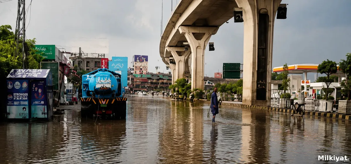
Heavy monsoon rain caused Nullah Lai and its connected drains to rise sharply on 17 August 2026, sending floodwater into homes across Mumtaz Town, Dhok Kala Khan, Banaras Colony, Afzal Town and Fauji Colony, with the Rawalpindi Water and Sanitation Agency declaring a rain emergency in the city. Around six feet of water reportedly accumulated inside dozens of homes in Mumtaz Town alone, according to WASA's Managing Director. The Pakistan Meteorological Department has warned that low lying parts of Islamabad and Rawalpindi remain exposed to further urban flooding through 20 August.
What Happened This Time
Water levels in Nullah Lai and its associated drains rose to around 20 feet at one point, prompting authorities to sound danger sirens and advise residents in vulnerable areas to move to safer locations. The situation was reported as particularly severe in and around Chaklala Cantonment, where rainwater and drain overflow entered residential streets and houses directly. Rescue teams retrieved several people stranded in the floodwater and moved them to safer locations, while vehicles, furniture and electrical equipment sustained significant damage in the worst affected homes. Several major roads and connecting streets across Rawalpindi were also inundated, slowing traffic across the city.
Why These Specific Neighbourhoods Keep Flooding
This is not a new problem for Rawalpindi, and understanding why is essential for anyone evaluating property in the affected corridor. Nullah Lai is a rain fed natural stream flowing through the city with a catchment area of roughly 235 square kilometres, drawing water down from the Margalla Hills bordering Islamabad through six major tributaries before it passes through Rawalpindi's densely populated low lying areas. Technical flood studies of the basin identify a specific danger threshold: flood inundation in areas like Dhok Charaghdin begins once water at the Gawalmandi Bridge gauge reaches 18 feet, a benchmark authorities and residents both track closely every monsoon season.
Rawalpindi's vulnerability is compounded by decades of encroachment along the waterway itself. Research examining the Lai Nullah's history has documented how bridges, construction debris and informal settlement have obstructed the stream's natural flow over time, a pattern researchers and historians studying the basin describe as a governance failure layered on top of the city's underlying geography, since Rawalpindi sits in a natural basin where multiple hillside streams converge before funnelling stormwater directly into these same populated neighbourhoods.
This week's flooding also sits within a documented, repeating history. The most catastrophic event on record struck on 23 July 2001, when 620 millimetres of rain fell on Islamabad in just 10 hours, triggering flooding along Nullah Lai that caused extensive loss of life and property and marked a turning point that led to the creation of a dedicated Lai Nullah flood control program. A similarly severe short duration event followed on 5 July 2008. Areas named in Rawalpindi's own district disaster management plan as historically vulnerable to Lai Nullah flooding include Dhok Hassu, Mehar Colony and the corridor along the M. Hussain Bridge, alongside the neighbourhoods affected this week.
What the Weather Service Is Warning
The Pakistan Meteorological Department has forecast continued rain across different parts of the country through 21 August, and has specifically flagged the possibility of further urban flooding in low lying areas of Islamabad and Rawalpindi through 20 August, alongside similar warnings for low lying parts of Mardan and Swabi. The department's own forecasting explains this pattern as driven by monsoon currents from the Arabian Sea and Bay of Bengal penetrating the upper and central parts of the country, occasionally reinforced by a westerly wave moving through the same region, a combination that has produced repeated flooding episodes across the twin cities throughout the current monsoon season according to the Pakistan Meteorological Department's official forecasting portal. Residents in vulnerable areas along Nullah Lai should treat this as an active warning window rather than a single, now concluded event.
Rawalpindi's district administration follows a defined emergency response protocol during these episodes. Under standard operating procedures set by the provincial government, teams from the local administration, the Water and Sanitation Agency, Rescue 1122, Civil Defence and health departments are dispatched to monitor Nullah Lai directly whenever water levels rise, a coordinated response structure overseen provincially by the Punjab Provincial Disaster Management Authority, which issues alerts to district administrations ahead of forecast rain spells and directs precautionary arrangements in low lying and flood prone areas specifically to reduce urban flooding risk.
What This Means for Property Buyers and Owners
Repeated flooding of this kind tends to weaken buyer and tenant demand in the specific pockets affected, and tends to sharpen scrutiny of a property's elevation, drainage and flood history well beyond the immediate cleanup period. The realistic near term impact for most affected households is repair cost and temporary disruption rather than a sudden, citywide shift in property prices, but for property directly within the historically flood prone corridor along Nullah Lai, this week's event adds another data point to an already well documented pattern rather than representing a one off surprise. This kind of infrastructure driven risk sits alongside other documentation and verification factors buyers in Rawalpindi already need to track, including the PLRA e-stamping disruptions that have separately affected property registrations in the same district this month, and the broader push toward faster resolution of pending revenue and ownership cases across Rawalpindi Division.
Buyer Checklist for Property Near Nullah Lai and Similar Drainage Corridors
Confirm the property's actual elevation relative to the nearest drain or nullah, not just its distance measured on a map, since low lying plots close to a waterway carry meaningfully higher risk than similarly close plots sitting at a higher elevation. Ask directly whether the specific street or block has flooded in past monsoon seasons, including in 2001, 2008, or more recent years, rather than relying on a general area reputation. Check how far the property sits from the nearest drain or tributary feeding into Nullah Lai, and treat proximity to any of the basin's six major tributaries as a genuine risk factor rather than only the main channel itself. For any property with a basement or semi basement level, assess flood risk separately and more conservatively, since basement levels are disproportionately vulnerable to water ingress even when the ground floor itself escapes serious damage. Ask about the condition and capacity of local drainage infrastructure serving the specific street, including whether WASA or the district administration has documented any recent desilting or encroachment clearance work in that specific stretch. Finally, treat any property in a neighbourhood named in this week's reporting, or in Rawalpindi's own district disaster management plan as historically vulnerable, as requiring the same level of flood specific due diligence as legal title verification, not as a secondary consideration, alongside the general documentation checks outlined in milkiyat.com's guide to verifying housing societies and property records.
Sources
- Wikipedia, Lai Nullah, background on catchment area, historical flood events and basin geography: https://en.wikipedia.org/wiki/Lai_Nullah
- Heinrich Boll Stiftung Afghanistan Pakistan, "Urban Flooding: A Case Study of Layi Nullah in Rawalpindi, Pakistan": https://afpak.boell.org/en/2026/02/13/urban-flooding-case-study-layi-nullah-rawalpindi-pakistan
- Punjab Disaster Management Authority, Rawalpindi District Disaster Management Plan, official document: https://pdma.punjab.gov.pk/system/files/DDMP%202025%20Rawalpindi.pdf
- Punjab Provincial Disaster Management Authority, official website: https://pdma.punjab.gov.pk/
- Pakistan Meteorological Department, official forecasting portal: https://www.pmd.gov.pk/en/
- International Flood Management technical case study, "Lai Nullah Basin Flood Problem, Islamabad," including the Gawalmandi Bridge flood threshold data: http://www.floodmanagement.info/publications/casestudies/cs_pakistan_nullah_full.pdf