News
Why Rawalpindi's Recurring Flooding Is a Governance Failure, Not Just Heavy Rain

By Mariam Khan
Real Estate Analyst
4 min read
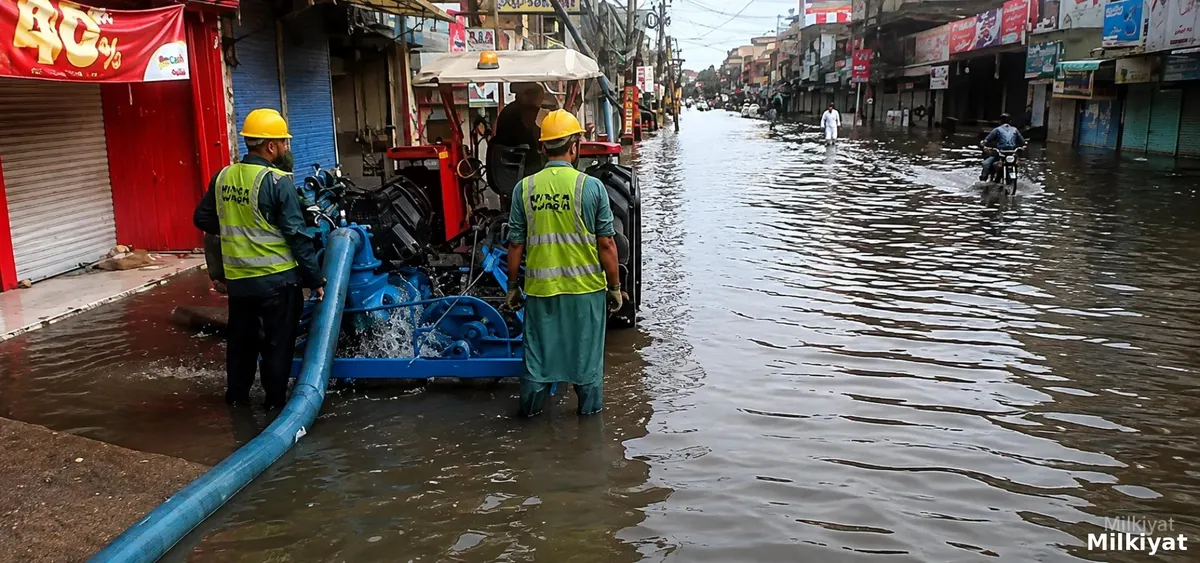
Rawalpindi's twin cities region experienced its heaviest rainfall of the current monsoon season this week, with heavy downpours pushing Leh Nullah to a high water level at New Kattarian, triggering warning sirens and sending water into homes, shops and markets across several low lying neighbourhoods. Notably, the nullah itself did not overflow its banks. Smaller drains and sewerage channels failed under the pressure instead, turning roads into streams and submerging vehicles across the affected areas. The Punjab Provincial Disaster Management Authority has separately continued to issue urban flooding alerts for Rawalpindi and other Punjab cities throughout the current monsoon spell.
Why This Cannot Simply Be Blamed on Exceptional Rain
The pattern this week reflects a deeper, structural problem rather than an unforeseeable natural event. Rawalpindi sits directly downstream of a catchment extending into Islamabad, and Leh Nullah's basin covers a total area of roughly 234.8 square kilometres, drawing water from the Margalla Hills bordering Islamabad before it reaches Rawalpindi's densely populated low lying neighbourhoods. When heavy rain falls on increasingly built up land across this catchment, large volumes of runoff descend rapidly toward the city, a hydrological reality that governs the basin regardless of which side of the Islamabad Rawalpindi boundary the rain actually falls on.
A Recurring Problem Dating Back Decades
Flooding along Leh Nullah is not a new phenomenon. According to background compiled on the waterway's history, a record 620 millimetres of rainfall fell on Islamabad in just 10 hours on 23 July 2001, triggering major urban storm flooding along the nullah through the twin cities, and a further severe rainfall spell between 4 and 9 July 2008 produced flooding on 5 July after 104 millimetres fell in just 100 minutes, with 162 millimetres recorded in five hours at the Pakistan Meteorological Department's Islamabad headquarters. This recurring history across more than two decades underscores that the risk itself has been well understood for a long time, even as individual flooding events are sometimes described afterward as exceptional.
How Disaster Management Is Meant to Work in Punjab
Punjab's Provincial Disaster Management Authority, established in 2010 and operating under the guidance of Pakistan's National Disaster Management Authority, exists specifically to enhance preparedness, response and recovery capability ahead of disasters including floods, and holds explicit authority to examine construction in a given area and direct compliance if building standards have not been followed. According to PDMA's own stated functions, the authority is meant to coordinate provincial departments, evaluate preparedness at all levels of government, and lay down guidelines for district level disaster management plans, precisely the sustained, structural role that recurring nullah flooding suggests has not yet been fully realised on the ground. Following the 2014 super floods across Punjab, PDMA and the Punjab Information Technology Board jointly built a dedicated flood disaster management system to improve data logging, satellite based inundation assessment and coordinated relief reporting across districts, a technical capability that exists in parallel to the more basic, recurring problem of nullah and drain maintenance itself.
What This Means for Property Owners
For anyone owning or evaluating property along Leh Nullah or the drains that feed into it, the practical lesson from this recurring pattern is that seasonal, pre monsoon cleaning efforts alone have not proven sufficient to prevent flooding in specific, previously known vulnerable locations. Property near any stretch of the nullah or its tributary drains should be evaluated with year round drainage risk in mind rather than only the presence of a cleanup programme earlier in the year, and buyers should ask directly whether a specific location has experienced repeat flooding or repeat encroachment problems across multiple monsoon seasons, since a single year's preparation has historically not been enough to break this cycle. Climate change increasing the likelihood of intense rainfall bursts makes this due diligence more, not less, important going forward, since the underlying catchment and drainage constraints are structural rather than something a single strong monsoon season creates on its own.
Sources
- Wikipedia, Lai Nullah, background on catchment area and historical flooding events: https://en.wikipedia.org/wiki/Lai_Nullah
- Wikipedia, Margalla Hills, background on the range forming the catchment's northern boundary: https://en.wikipedia.org/wiki/Margalla_Hills
- Wikipedia, Provincial Disaster Management Authority (Punjab), background on formation and mandate: https://en.wikipedia.org/wiki/Provincial_Disaster_Management_Authority_(Punjab)
- Punjab Provincial Disaster Management Authority, official website and live flood alerts: https://pdma.punjab.gov.pk/
- Punjab Provincial Disaster Management Authority, official overview of functions: https://pdma.punjab.gov.pk/overview
- Punjab Information Technology Board, Punjab Floods Disaster Management System: https://pitb.gov.pk/pfdms