Guide
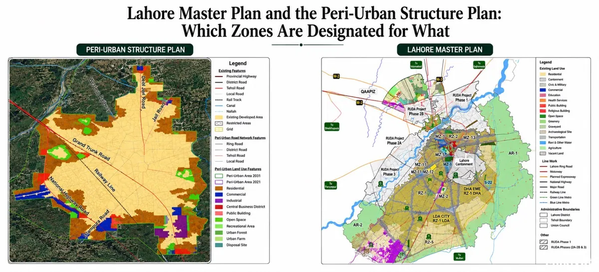
Lahore Master Plan and the Peri-Urban Structure Plan: Which Zones Are Designated for What

By Maham Imtiaz
Real Estate AnalystVerified author
18 min read
Short Answer:
Lahore's land is controlled by two linked documents. The Master Plan sets the broad land-use picture for the whole controlled area and sorts every parcel into ten classes, residential, commercial, mixed-use, industrial, institutional, open space and recreational, peri-urban, special development zone, agricultural and notified area. The Peri-Urban Structure Plan is the detailed rulebook for one of those classes: the belt of farmland between the built-up city and open countryside that is expected to urbanise within twenty years. Inside that belt, what you may legally build is decided by the structure plan, not by ordinary urban zoning. Every class carries three tiers of use, permitted (allowed as of right), permissible (only with Planning and Design Committee approval and a fee) and prohibited (never allowed). As of August 2026 LDA is still approving schemes under the amended Master Plan of Lahore Division 2016, because the 2050 plan was set aside by the Lahore High Court and is under revision. For a buyer, the gap between "peri-urban" and "agricultural" is the gap between a plot with a legal future and a plot without one.
Two documents, two different jobs
Most people in Lahore use "master plan" as a catch-all term. In LDA's own paperwork it is narrower than that. Under the Lahore Development Authority Act 1975, downloadable in full from LDA's official downloads page, a master plan is defined as a land-use plan of an area, and the definition expressly includes a structure plan, an outline development plan, a spatial plan, a peri-urban structure plan and a metropolitan plan.
So the Peri-Urban Structure Plan is not a rival document competing with the Master Plan. It is a component of it, the zoomed-in layer for the city's edge.
The Master Plan is the strategic instrument. It covers the whole of Lahore Division, Lahore, Kasur, Sheikhupura and Nankana Sahib, and sets the outer envelope of urban growth: how many people the division must absorb, which side of the city takes them, where ring road and rail corridors run, and which land stays agricultural.
The Peri-Urban Structure Plan is the operational layer for a single band of land. LDA is required to permit uses in a peri-urban area only in accordance with the approved structure plan, and may not allow a use that is neither permitted nor permissible under it.
That distinction is commercial, not academic. The Master Plan tells you whether an area is inside the growth boundary at all. The structure plan tells you what you may actually do on the plot once it is. And the edge is where almost all of Lahore's new housing supply comes from: DHA's later phases, LDA City, Bahria Town and the schemes strung along Ferozepur Road, Multan Road, Defence Road, Bedian Road and the Ring Road corridor were all, at some point, peri-urban land.
Which plan is actually in force right now
This is the part buyers get wrong most often, because the headlines and the legal position have not matched for several years.
The Lahore Division Master Plan 2050 was prepared by international consultants, completed in 2022, approved by the then chief minister in October 2022 and notified, then challenged in the Lahore High Court, which suspended its enforcement in January 2023 and later set the notification aside, directing LDA to revise the plan and have it reviewed. Petitioners argued that agricultural land had been urbanised without justification and that the approval favoured developers.
Since then the operative document has been the older plan. In May 2026, LDA's Chief Metropolitan Planner confirmed that the authority was still using the Master Plan 2016, itself a revision of the Punjab Capital Master Plan 2004-2021, for approving housing schemes and land subdivisions, while consultants revised the 2050 plan against the 2023 census, the earlier draft having been built on 2017 figures. The stated intention was to submit the final draft by 31 May 2026, hold the environmental public hearing, take it to the LDA governing body in late June and enforce it from 1 July 2026. New built-up areas that emerged in the interim were to be folded into the "brown" residential and mixed-use category, and development inside the Ravi Riverfront area reconciled with RUDA's own plan. The full account is in Dawn's report on the Lahore Division Plan-2050.
Two practical consequences follow:
- A zoning map you saw online may not be the one LDA is applying. Copies of the 2050 land-use map have circulated since 2022. Until the revised plan is formally notified, LDA's approvals desk works off the 2016 document plus the Land Use Rules and Regulations 2020. Anyone selling you a plot "as per Master Plan 2050" is selling you a draft.
- A plot's zoning can change when the new plan lands. That is a risk and an opportunity, and it is why serious buyers check the notified status rather than the announced status. Dawn's 2025 report on Lahore's master plan being in limbo since 2023 sets out how long the city has been running on the amended 2016 plan.
The ten zone classes LDA actually uses
Under the LDA Land Use Rules 2020, land inside the controlled area is sorted into ten classes, and each class carries the permitted / permissible / prohibited structure described above. That three-tier engine repeats in every class. The full rule text, including the land use tables, is published on LDA's official downloads page.
| Zone class | Typical permitted uses | Typical permissible uses |
|---|---|---|
| Residential | Houses, apartments, playgrounds and parking, graveyards, horticultural nurseries, urban farms, old-age homes and orphanages | Corner and neighbourhood shops, places of worship, day-care and pre-schools, small dispensary, library, rehabilitation facilities |
| Commercial | Plazas, shops, markets, offices, restaurants, hotels up to three star, banks, showrooms, parking plazas | Educational institutions, cinemas, banquet halls (minimum plot sizes apply), private hospitals, petrol pumps, auto workshops |
| Mixed-use | Shops or offices on lower floors with residences above, along designated corridors | As specified for the corridor concerned |
| Industrial | Cottage, light and medium industry, warehousing and cold storage, distribution centres, building material stores, industrial parks, grid stations, loading areas | Petrol pumps, gas and LPG filling stations, essential worker housing, oil depots, restaurants, hospitals, auto workshops |
| Institutional | Schools, colleges, universities, hospitals, government offices, public and religious buildings | As specified in the rules |
| Open space and recreational | Parks, green belts, sports grounds, playgrounds, urban forest | Limited ancillary facilities |
| Peri-urban | Whatever the approved Peri-Urban Structure Plan says | Whatever the approved Peri-Urban Structure Plan says |
| Agricultural | Crops, orchards, pasture, dairy, poultry and fish farms, forest, nursery, tubewell, existing villages, corner shop | Farmhouse, brick kiln, basic health unit, country club, recreational park, zoo or wildlife park |
| Special development zone | As set by the sponsoring authority, CBD, RUDA's Ravi Riverfront and comparable project areas | As per that authority's framework |
| Notified area | Governed by the specific notification — heritage, environmentally sensitive, public institutional, restricted, intercity service | As per that notification |
Two rows deserve a second look.
Industrial is the one class where the rules name outright bans rather than leaving prohibition to inference: storage, packing or manufacture of blasting powder, fireworks, sulphur, gunpowder, nitro-compounds, ammunition, dynamite, explosives, phosphorus, bombs and similar hazardous goods.
Peri-urban is the row that deliberately refuses to fix its own content. That is the entire point of the structure plan.
It is also worth noting what "residential" does not include. A warehouse, a marriage hall or a factory unit on a residential street is prohibited, which is why so many home-based businesses in Johar Town and Model Town sit one complaint away from a sealing notice.
What the Peri-Urban Structure Plan actually is
The rules define a peri-urban area as land spanning the landscape between contiguous urban development and rural countryside, with low population density, predominantly under agricultural use, and likely to be urbanised within the next twenty years.
Read that definition slowly. It is not a description of what the land is. It is a prediction of what the land will become. Peri-urban is agriculture with a scheduled expiry date.
The structure plan makes the prediction operational. LDA prepares it using satellite imagery and field survey, marking the boundaries of existing built-up areas and approved schemes onto a base map. The external boundary of the belt is drawn on three criteria: the direction and trend of urban sprawl, the population growth rate, and the requirements of urban development for the next twenty years.
The plan itself must contain three things, proposed road networks, a division of the area into blocks, and the proposed land uses for those blocks.
It then goes through a public process: objections invited through LDA's website and newspapers, a public hearing, scrutiny by the District Planning and Design Committee, approval, and notification within seven days. Once notified, a certified copy can be obtained on payment of a fee, and the rules require review at least once every five years.
Combined with the land-use classification map and the notified agricultural area, the structure plan feeds into the district planning map, the single document that shows, for any point in the district, which regime applies.
Peri-urban versus agricultural: the distinction that decides value
If you take one thing from this article, take this.
Agricultural area is the land between the outer limit of the peri-urban belt and the outer limit of the controlled area. Its permitted uses are farming uses. Its permissible uses top out at a farmhouse, a brick kiln, a basic health unit, a country club or a recreational park. A residential housing scheme is on neither list.
Peri-urban land is a different animal. The reclassification tables in the land-use rules allow peri-urban land to be converted to residential, commercial, industrial, corridor and several notified categories. Agricultural land carries no such matrix.
This is why two plots that look identical from the road, same crop, same soil, same access track, can differ enormously in price and in risk. One sits inside a belt the authority has already earmarked for urbanisation. The other does not.
It is also why the single most useful question to ask a dealer is not "is this near the Ring Road?" but "which side of the peri-urban boundary is this on, and can you show me the notified map?"
Why the peri-urban belt is where buyers get hurt
The peri-urban zone is priced like the city and regulated like the countryside. That gap is the entire business model of unapproved schemes on Bedian Road, Raiwind Road, Multan Road and the Sheikhupura side. Three things go wrong repeatedly.
Zoning mismatch. A scheme is marketed with a full urban layout, commercial strip, apartment blocks, marriage hall site, on land whose structure plan permits none of it. The plots sell; the approvals never come.
Green-to-brown assumptions. Buyers assume farmland next to an approved scheme will "obviously" be converted. It can go the other way, and recently has.
Exit failure. A peri-urban plot without valid structure plan permission cannot get a building plan approved, which means it cannot get a completion certificate, which means the resale pool shrinks to buyers who do not check. The discount shows up at exit, not at entry.
Verification is not optional here. Our Lahore property market guide 2026 covers the approval and revenue-record checks every Lahore buyer should run before a token payment, and our walkthrough of the NAB online property information system shows how to cross-check a society against what a developer is selling.
What conversion costs
Changing a plot's classification is not free, and the fee structure tells you how the authority values each use. Under the land-use rules, conversion fees are calculated as a percentage of commercial land value in the vicinity, and they vary sharply by target use:
- Peri-urban or intercity service area to residential: a nominal percentage of commercial land value.
- Peri-urban or intercity service area to industrial: a mid-range percentage.
- Residential, industrial, peri-urban or intercity service area to commercial: the highest band by a wide margin.
- Conversion to educational or healthcare institutional use: a middle band, with exemptions available for charitable, tax-exempt or low-income-area institutions.
The gap between the residential and commercial rates is why so much of Lahore's commercialisation friction happens on main roads: the uplift is worth the fee, and the fee is large. Rates are revised from time to time, so confirm the current notified figures with LDA before budgeting. Our guide to LDA commercialisation and land use conversion walks through eligibility, the permanent versus annual fee structures and the full application process.
The rules also lock certain things down. LDA cannot reclassify land use in an approved scheme or industrial estate for twenty years from approval, cannot convert commercial or residential land to industrial use, and cannot reclassify plots reserved for schools, hospitals, police stations, post offices, places of worship, graveyards or public parks. Those reservations are meant to be permanent, a useful check when a developer offers you a "converted" plot on what the layout shows as a park.
Where Lahore's growth is actually being pushed
The zoning debate in Lahore is really a debate about direction of growth, and the 2050 plan made a clear choice.
The draft proposed accommodating roughly nine million of a projected 12.6 million additional people inside Lahore district's administrative boundaries, allowing only very limited horizontal expansion next to existing urban areas, with the remaining 3.6 million housed outside the district on the northern side. Dawn covered the split in its report on the draft Master Plan of Lahore Division-2050. The published direction also includes a new city centre in Gulberg, a regional ring road with a parallel rail corridor, and the stitching together of plans belonging to the Walled City of Lahore Authority, the Punjab Central Business Districts Development Authority and RUDA, bodies that currently zone their own areas independently of LDA.
That northward push is why Sheikhupura, Kala Shah Kaku and Muridke keep appearing in investor conversations. It also came with a green-belt correction that cuts the other way: LDA said it had moved around 27,000 acres of undeveloped brown area on the northern side into green, agricultural designation, plus another 6,000 acres along the BRB Canal, reported by Dawn as 33,000 acres of housing land declared green. Land that had been notified for housing became agricultural and strategic reserve.
In planners' shorthand, "brown" means land allocated for residential and mixed-use development and "green" means land held back for agriculture and open space. Those two colours moving across a map is the single most consequential thing that happens to land values in this city.
For how existing localities compare today, see our DHA Lahore complete area guide 2026, our budget breakdown of what Rs 1 crore actually buys in Lahore, the decade of per-marla data in Lahore plot prices 2016-2026, and our ranking of the best areas to live in Lahore.
A practical checklist before you buy on the edge
- Get the exact revenue identifiers. Khasra or khewat number, mauza and tehsil. A society block name is not a location.
- Ask for the zone, not the address. Get the classification from LDA's Metropolitan Planning Wing in writing against those identifiers: residential, peri-urban, agricultural or notified.
- Check which plan is actually in force. Confirm whether LDA is applying the 2016 plan or a notified 2050 plan on the date of your transaction.
- See the notified map, not a brochure map. Certified copies are obtainable from LDA on payment of a fee. Layout plans get quietly amended; brochures do not.
- Confirm the scheme is approved and your block sits inside the sanctioned boundary. Plots just outside an approved boundary look identical on a layout plan and are worth very little.
- Check reserved plots. If the site is marked for a park, school or graveyard in the approved layout, it cannot be lawfully reclassified.
- Confirm which authority governs the land. LDA, DHA, a cantonment board, RUDA or PCBDDA — each runs its own zoning regime.
- Price in the conversion fee. If your plan depends on commercial use, the fee is a real cost, not a formality.
- Budget the build, not just the land. Zoning permits a use; construction costs and post-construction approvals come on top. Run the numbers through our Lahore construction cost calculator.
Our full library of Lahore area guides covers the individual schemes in more detail.
Frequently asked questions
Q1. Is the Lahore Master Plan 2050 legally in force?
A. Not as a settled instrument. It was approved and notified in 2022, suspended by the Lahore High Court in January 2023 and the notification later set aside for revision. As of May 2026 LDA confirmed it was still working under the amended Master Plan 2016 while a revised draft was finalised against the 2023 census, with a stated target of enforcement from 1 July 2026. Confirm the current notified status with LDA before relying on it.
Q2. What is the difference between a Master Plan and a Peri-Urban Structure Plan?
A. The Master Plan sets the growth strategy and broad zoning for the whole division. The Peri-Urban Structure Plan governs the transition belt between the built-up city and agricultural land, and determines which uses are permitted or permissible on that belt.
Q3. What do "permitted", "permissible" and "prohibited" mean?
A. Permitted uses are allowed as of right. Permissible uses may be allowed by the District Planning and Design Committee subject to conditions and payment of the applicable fee. Prohibited uses are neither permitted nor permissible and cannot be approved at all.
Q4. Can I build a house on agricultural land inside the controlled area?
A. Not as a permitted use. A farmhouse is a permissible use requiring committee approval, but a residential subdivision is on neither the permitted nor the permissible list for agricultural area.
Q5. Does peri-urban status guarantee my land will be converted?
A. No. It means the land sits inside a belt planned for urbanisation and that the structure plan governs what may be approved there. Approval still runs through the committee process and the fee schedule.
Q6. Which zone is safest for a first-time buyer?
A. Land inside an approved scheme in a residential or mixed-use zone, with a valid layout plan and a clean approval history. Peri-urban and agricultural land can be profitable, but they carry approval risk that most first-time buyers are not positioned to price.
Q7. What is the practical difference between "brown" and "green" area?
A. Brown is land allocated for residential and mixed-use development. Green is land held back for agriculture and open space. A shift from one to the other changes what can legally be built, and therefore changes the land's value.
Q8. How often are these plans updated?
A. The rules require periodic review of the land-use classification map, the peri-urban structure plan and the district planning map at least once every five years.
Q9. Where can I read the official documents myself?
A. The LDA Landuse Rules 2020, the Land Use Regulations 2020, the Agricultural Area Notification and the LDA Act 1975 are all downloadable from LDA's official downloads page, linked in the sources below. Certified copies of the notified maps are obtained from LDA on payment of a fee.
The bottom line
Lahore's zoning system is not one map. It is a hierarchy: the Master Plan sets the classes, the Peri-Urban Structure Plan fills in the belt where the city is actually growing, the agricultural notification draws the outer line, and the district planning map stitches all three together.
Zoning is not paperwork you sort out later. It sets the ceiling on what your land can ever become, and on Lahore's edge that ceiling is often far below the price being asked. Prices out there are, in the end, a bet on which side of those lines a piece of land falls, and on whether the line will move. Buy the zone first and the plot second, and read the zoning before you read the brochure.
Sources and further reading
- LDA official downloads page, direct downloads for the LDA Landuse Rules 2020, LDA Land Use Regulations 2020, the Agricultural Area Notification and the Lahore Development Authority Act 1975 (as amended)
- Dawn — Lahore Division Plan-2050 likely to be enforced from next fiscal year
- Dawn — Lahore's master plan in limbo since 2023
- Dawn — Lahore Master Plan: 33,000 acres of housing projects' land declared green areas
- Dawn — Draft Master Plan of Lahore Division-2050: 3.6m of 12.6m additional population to stay out of city district