Guide
Faisal Town Phase 2 Master Plan Explained
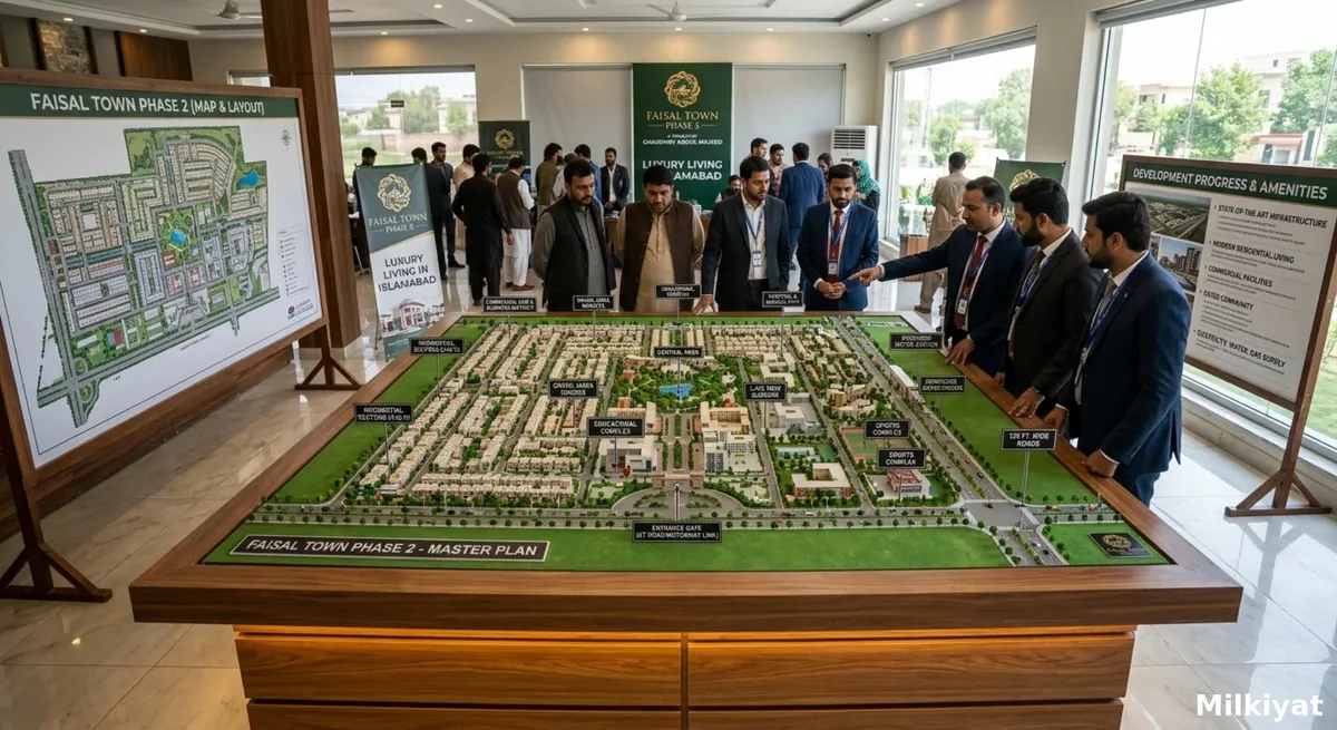

This guide covers the master plan structure only. For one sector, see its own guide.
Overview
The master plan of Faisal Town Phase 2 is easy to describe and hard to pin down. The developer's own page names 25 sectors, two blocks and seven districts over "more than 80,000 kanals", with 200,000 kanals as the aim. It doesn't name a designer, and it doesn't say how much of that land is residential, commercial or green.
You may have seen the plan credited to the Meinhardt Group, or described in "zones". The developer's page names no designer. We also found no published description of "Zones I to V". So this guide sticks to the structure the developer actually publishes, and says plainly where the numbers stop. Plots currently on offer are on the Faisal Town Phase 2 listings page.
One caution first. A published master plan is not an approved layout plan. The developer's own page says the Phase 2 NOC is not approved by the Rawalpindi Development Authority (RDA).
What the master plan names
The developer's master plan page lists these layers:
| Layer | Count | What the page names |
|---|---|---|
| Blocks | 2 | General Block, Overseas Enclave |
| Districts | 7 | Commercial Business District (CBD), Commercial District East, West and South, Lake City, Education City, Sports City |
| Sectors | 25 | A to E, F to J, K to O, P to T, U to Y |
The developer's main page also gives a payment plan for Sector O, the Model Block, so a buyer will meet three block names in practice. The residential plots come in six sizes, from 5.56 marla (25 x 50 ft) to 2 kanal (75 x 120 ft). The commercial plots come in six sizes, from 5.33 marla (shopping centre) to 13.33 marla (commercial markaz and main boulevard).
Marketing pages don't always agree with this. Some quote 35 or more sectors, or 45 or more blocks and sectors. The developer's own page lists 25 sectors, so go by that and ask for the layout plan if a seller uses a different number.
How the sectors, blocks and districts fit together
The three layers do different jobs. Sectors are the lettered divisions, A to Y, grouped in five runs of five letters. Blocks are named sub-areas, such as the General Block and the Overseas Enclave, and Sector O doubles as the Model Block that the payment plan refers to. Districts are themed areas: a business district, three commercial districts, and one each for lakeside living, education and sports.
The developer's page doesn't say which sectors sit inside which district, or where the districts lie on the map. So a sector letter tells you where your plot is filed, not what stands next to it. For that you need the layout plan with your plot marked.
Who designed it
The developer's master plan page says "a team of expert architects and town planners" is behind the plan and names no firm. Other Faisal Town-branded and dealer pages credit the Meinhardt Group. Milkiyat couldn't confirm that from a developer document or from Meinhardt, so treat the credit as a claim.
As for "zones": the developer's structure is sectors, blocks and districts. A description of Zones I to V didn't turn up in any source we could check. If you hold the master plan document that uses those names, send it to us and we will add a section.
How big is the master plan?
The figures in circulation don't line up, and they mean different things:
| Figure | Where it appears | What it is |
|---|---|---|
| 80,000+ kanals | Developer's master plan and main pages | Land the society covers |
| 200,000 kanals | Same pages | Management's aim |
| 25,000 to 30,000 kanals | Milkiyat's Phase 2 guide | Initial layouts, not an RDA figure |
| 7,300 kanals | Developer claim of October 2022 | Reported RDA NOC, unverified |
The first two are the developer's own. The last is a claim we haven't verified. Our Faisal Town Phase 2 NOC guide takes it apart.
What the kanal figures mean in acres
A kanal is not one fixed size in practice. The developer's own plot sizes imply one: a 2-kanal plot is 75 x 120 ft, or 9,000 sq ft, so its kanal is 4,500 sq ft. On that basis 80,000 kanals is 360 million sq ft, about 8,265 acres, and 200,000 kanals is about 20,661 acres.
The Punjab revenue kanal is 5,445 sq ft, one-eighth of an acre. On that measure the same figures are 10,000 and 25,000 acres, about 21% more land. This is our arithmetic, not a developer figure. It matters because the two measures give very different areas, so ask which kanal a seller or a map is using before you compare sizes.
Milkiyat.com finding: land use can't be measured, and the plan is 40% of its own goal
The plan names land uses but gives no areas for any of them, so a residential, commercial and green split can't be calculated from the developer's pages. That is the finding. The nearest arithmetic the published numbers allow is this:
- 80,000 ÷ 200,000 = 0.40. Even on the developer's own figures, the 80,000 kanals it covers are 40% of the 200,000 it aims for.
- 7,300 ÷ 80,000 = 0.091. If the 2022 letter is genuine, it would cover 9.1% of the land the developer says it covers.
- Four of the seven districts are commercial (the CBD and the East, West and South districts). That is a count of districts, not a share of land, so don't read it as one.
If you have the plan's area statement, with kanals per land use, we will compute the shares.
Reading the plot sizes in the plan
The developer's sizes use a marla of 225 sq ft. A 25 x 50 ft plot is 1,250 sq ft, which gives 5.56 marla. On the Punjab revenue marla of 272.25 sq ft, the same plot is 4.59 marla.
The 2-kanal plot has the same issue: 9,000 sq ft is 2 kanal on the developer's measure and about 1.65 kanal on the revenue measure. Compare plots by their dimensions in feet, not by the marla or kanal label, and check the dimensions on your allotment letter against the plan.
What the plan promises for each use
The developer's master plan page makes these statements. They are plans, not delivered facilities:
- Residential: six plot sizes across the sectors and blocks.
- Commercial: the CBD, three commercial districts and commercial areas inside blocks and sectors. Milkiyat's guide records basement, ground and six-floor plots in the markaz, with taller mixed-use zones planned.
- Education: a dedicated educational plot in every block and sector, plus Education City.
- Parks and mosques: planned in each block and sector.
- Health: hospitals and medical facilities planned.
- Sports and leisure: Sports City and Lake City.
- Roads: a 350-foot-wide boulevard, which the developer says is fully developed and operational.
The page gives no area, count or timeline for any of these. The boulevard is the one item the developer describes as already operational. Everything else on the list is a promise on paper.
That gap shapes how you should read the plan. A plan that names a hospital, a park and a school in every block tells you what the developer intends to build. It doesn't tell you where they sit, how large they are, or when they will open. Ask what is planned beside your plot, because that, not the headline plan, is what you will live next to.
How much has been built?
The developer says almost all groundwork across the society is complete, and its FAQ says 90% of the land is levelled. Neither claim has sector-level detail. Milkiyat's own Faisal Town Phase 2 guide lists earthwork as complete in Sector O, Sector P and Sector X, and bridges under construction in Sectors Q and R. We haven't verified those either. The developer gives possession as 3 to 4 years for the whole scheme, with no date for any sector.
A master plan is not an approval
RDA's public advisory lists launching a scheme without formal approval, and not getting the layout plan approved by the competent authority, among the violations it pursues. RDA has also said that a pending application is not formal approval. The developer's page says the NOC is not approved.
So a plan you can see on a website doesn't tell you that your plot will stay where the plan shows it, or that the land use beside it will stay as drawn. Our guide to verifying a Faisal Town Phase 2 file shows how to check the RDA record.
It helps to keep three documents apart. A master plan shows the developer's intent for the whole scheme. A layout plan shows the plots, roads and open spaces in a defined area, with plot numbers. An approval is the competent authority's decision on that layout plan. A buyer needs the second and third, and a master plan image supplies neither.
A worked example: checking one offer against the plan
Say a dealer offers you a 25 x 50 ft plot in a sector you have never heard of. Here is how to use what is above, as an illustration and not a record of any real plot.
First, find the sector letter on the developer's list of 25, A to Y. If the letter is outside that range, the offer doesn't match the developer's published plan. Second, ask which block or district the sector belongs to, since the developer's page doesn't say. Third, ask for the dimensions in feet and compare them with the 1,250 sq ft that a 25 x 50 plot should measure. Fourth, ask for the layout plan and the RDA status of that layout, and get both in writing before you pay anything.
Checks before you rely on the master plan
- Ask which sector, block or district your plot sits in, and get it in writing.
- Ask for the master plan or layout plan with your plot marked, and its date.
- Ask what is planned on each side and across the road from your plot.
- Ask whether the layout plan you are shown is the one RDA has approved.
- Compare the plot number and sector on your allotment letter with the plan.
- Check RDA's live record before you pay. If you are looking at commercial plots, compare with commercial properties for sale in Islamabad.
FAQs
Who designed the master plan?
The developer names no designer. Other pages credit Meinhardt Group, which Milkiyat couldn't confirm.
How big is Faisal Town Phase 2?
The developer says 80,000+ kanals, with 200,000 as the aim. Neither figure is RDA-verified.
How many sectors are there?
The developer lists 25, A to Y, plus two blocks and seven districts.
What are Zones I to V?
We found no published description of them. The developer uses sectors, blocks and districts.
What share is residential, commercial and green?
The developer publishes no areas, so the shares can't be calculated.
Is the master plan approved?
Not on the evidence we can verify. The developer's page says the NOC is not approved.
Where are the commercial areas?
The CBD and the East, West and South districts, plus areas inside blocks and sectors. No map coordinates are published.