Guide
Margalla Enclave Plot Topography: Slope, Retaining Walls & Drainage Checks
Real Estate Analyst
10 min read
A practical guide to plot slope, retaining walls, earthwork and drainage conditions in Margalla Enclave Islamabad.
Overview
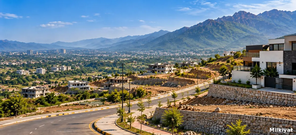
Margalla Enclave lies near the Margalla Hills, and its terrain is not uniformly flat. The project environmental assessment describes uneven ground, gullies and ravines in places, and a general slope towards the south-west. These conditions can affect excavation, retaining-wall design, road access and rainwater flow, so buyers should assess the actual plot rather than assume all streets have similar levels.
This guide explains the available terrain information, demonstrates how slope can affect illustrative earthwork quantities, and outlines practical checks for retaining walls, drainage and site conditions. For the wider project background, location and general information, read the Margalla Enclave Islamabad guide.
To compare properties being advertised, browse Margalla Enclave listings on Milkiyat. Treat listings as leads for further research, not proof of a plot’s exact location, ground levels, ownership, possession, utilities or drainage condition.
1. What the project documents say about the terrain
The environmental assessment filed with Pak-EPA records the following site-wide information:
| Feature | What the assessment reports |
|---|---|
| Highest point | 1,998 ft in the north-east |
| Lowest point | 1,609 ft in the south-west |
| Surface | Uneven and undulating, with gullies and ravines in places |
| Soil and rock | Clay and shale, silty sandy clay, sand, gravel, boulders and siltstone or sandstone |
| Groundwater | Approximately 160–450 ft below the surface |
| Drainage feature | Gumrah Kas Nullah crosses the area; channelisation is planned in the assessment |
| Lake | An existing natural lake is recorded on site |
| Heaviest rainfall | July and August |
The difference between the reported highest and lowest points is 389 ft (1,998 minus 1,609). This is a scheme-wide elevation range, not the slope or height difference of a particular plot. It does, however, show why buyers should not assume that every street or plot has the same ground level. Compare older drawings with the current version supplied by the relevant authority.
2. How slope affects plot levels and earthwork
Slope is commonly expressed as a percentage. A 5% slope means a vertical change of 5 ft over a horizontal distance of 100 ft. For a simple illustration, multiply the plot depth by the slope percentage to estimate the fall across that depth.
| Illustrative plot depth | Fall at 2% slope | Fall at 5% slope | Fall at 10% slope |
|---|---|---|---|
| 45 ft (5 marla example) | 0.9 ft | 2.25 ft | 4.5 ft |
| 65 ft (10 marla example) | 1.3 ft | 3.25 ft | 6.5 ft |
| 90 ft (1 kanal example) | 1.8 ft | 4.5 ft | 9.0 ft |
These numbers represent a simple fall along the plot depth, not a construction recommendation. A 1 kanal example on a 5% slope would have about 4.5 ft of level difference from one end to the other. Whether the design uses steps, a cut, fill or a retaining structure depends on the measured levels, road level, neighbouring plots, soil and approved building design.
For a simplified rectangular plot on a uniform slope, an estimate of cut needed to form a level pad—assuming cut and fill balance—is:
Approximate cut volume = width × slope × depth² ÷ 4
Using a 5% slope for illustration gives the following results:
| Example plot | Calculation | Approximate cut volume (and comparable fill) |
|---|---|---|
| 5 marla (25 × 45 ft) | 25 × 0.05 × 45² ÷ 4 | 633 cu ft (about 23 cu yd) |
| 10 marla (35 × 65 ft) | 35 × 0.05 × 65² ÷ 4 | 1,848 cu ft (about 68 cu yd) |
| 1 kanal (50 × 90 ft) | 50 × 0.05 × 90² ÷ 4 | 5,063 cu ft (about 188 cu yd) |
This is a simplified geometric estimate, not a contractor's quantity or cost. It assumes a uniform slope and a level pad where cut equals fill; actual quantities depend on ground shape, compaction, retaining structures and finished-floor level. Disposal, imported fill, haulage and engineering work are excluded. Obtain a site-specific estimate before budgeting.
Earthwork can increase quickly as plot depth increases because the simplified calculation depends on depth squared. Therefore, comparing only plot prices can hide meaningful site-preparation differences. For building-related requirements, refer to Milkiyat's guide to bylaws, map approval and construction costs.
3. Retaining walls: what buyers should check
A retaining wall holds soil where two areas sit at different levels. It may be needed on a side slope, where the road is lower, or where neighbouring land is higher. A listing photograph or sector name cannot establish the need for one.
Before design or construction, ask a surveyor to record the levels at all four plot corners, the road edge and relevant adjoining ground. This helps establish the height differences that the design must address. Also check where the legal boundary falls: a wall placed across a shared line can create a dispute about land, construction responsibility and maintenance. Do not assume that a visible wall marks the official boundary.
Clay and shale are among the materials mentioned in the assessment. Their response to water and loading depends on the actual ground conditions, so retaining wall foundations and drainage should be designed by appropriately qualified professionals. Do not copy a neighbour's wall design because soil and loading conditions can differ.
No fixed retaining-wall price is provided here because cost depends on wall length and height, design, soil, access and materials. Ask for written quotations based on the same measured drawing and technical specification, and confirm whether excavation, drainage, reinforcement and finishing are included. For plot boundary measurement procedures, see the separate plot demarcation and site survey guide.
4. Drainage: follow the water
The environmental assessment identifies flooding along Gumrah Kas as a climate-related risk and discusses measures intended to manage runoff. These include:
- Nullah channelisation, informed by hydraulic and hydrological studies.
- Check dams to slow or retain rainwater.
- Diversion of rainwater towards the on-site lake to support groundwater recharge.
- Rainwater harvesting, with the assessment citing calculated surface runoff of 4,182.4 cusecs.
These are measures described in the assessment; the document alone does not confirm that every work has been completed or that a particular street is protected. The land-use table allocates 215.56 kanal to the nullah and lake combined (2.16% of the area). Confirm current works with the authority.
Ask these questions before committing to a plot:
- Does the current layout place the plot near a nullah, gully line or lake corridor?
- Which direction does water flow from the road and adjoining land?
- What is the current status of drainage work in this part of the scheme?
- Where will roof water and surface runoff discharge after construction?
- Is a stormwater drain present on the street, and where does it lead?
The assessment contains differing descriptions of the lake: its text refers to a 500-kanal lake associated with the existing natural lake, while the land-use table groups 215.56 kanal for the nullah and lake together. These figures are not directly interchangeable. Until the authority provides a final, current design clarifying the area and scope, treat the final lake size as unconfirmed. Do not infer a plot's flood safety from the lake's advertised size or presence alone.
5. A practical site inspection checklist
If possible, visit the plot once in dry weather and again after rainfall. A visit can identify issues that need further investigation.
- Water marks or silt: Look at road edges, walls and low parts of the plot for signs that water has collected or flowed through.
- Gullies and channels: Check whether a natural depression or drainage path crosses or borders the plot.
- Standing water: Note low corners and areas where runoff appears to remain after rain.
- Exposed soil or rock: Record visible material at cut edges, rather than assuming it represents the whole plot.
- Erosion: Look for washed-out soil along slopes, road shoulders and unfinished boundaries.
- Road-to-plot level: Ask a surveyor to measure the difference instead of estimating it by eye.
- Neighbouring levels: Check whether nearby plots sit substantially higher or lower and whether their runoff could affect the site.
- Drainage outlet: Ask where the plot's roof and surface water can lawfully and safely discharge.
For a basement or deep foundations, arrange a site-specific soil investigation. The assessment mentions boulders and hard rock at depth but does not locate them on individual plots. Keep dated photographs, survey reports, soil reports and written replies from the authority. Ask sellers or agents to support claims about levels and drainage in writing.
6. What still needs plot-specific verification
A scheme-wide assessment cannot confirm the condition of an individual plot. Before relying on a seller’s claim, obtain the current layout and arrange suitable site checks: a surveyor can measure levels, while qualified professionals can assess soil, foundations, retaining structures and drainage. Ask the responsible authority to confirm the status of relevant infrastructure in writing. Listings and marketing maps are not substitutes for these checks.
7. Where to look next
For available properties, browse Margalla Enclave listings on Milkiyat and use the relevant plot details to guide your further checks.
Frequently asked questions
Is Margalla Enclave flat?
No. The assessment describes uneven, undulating terrain. The exact level and slope of an individual plot require a site-specific survey.
Will I need a retaining wall?
It depends on measured levels, the road and neighbouring plots, soil and the proposed building design. Obtain survey readings and professional advice before deciding.
How much earthwork might a sloping plot need?
Section 2 provides illustrative calculations for different plot sizes. Actual quantities require measured levels and a site-specific design; do not use the examples as contractor quantities.
Is there a flood risk?
The assessment identifies flooding along Gumrah Kas as a risk. Confirm the current status of drainage works and check the plot’s location and runoff route with appropriate professionals.
How much does a retaining wall cost?
There is no single reliable price without a design. Wall height and length, soil, foundation, drainage, access and materials all affect the quote. Compare written quotations based on the same drawing and specification.
Related Margalla Enclave guides
- Margalla Enclave Plot Demarcation and Site Survey: What Buyers Should Verify
- Building a House in Margalla Enclave: Bylaws, Map Approval and Construction Cost
- Margalla Enclave Development and Possession Status
Disclaimer: This article provides general property information, not a plot-specific survey, engineering opinion or guarantee of drainage safety. Readers should independently verify current layouts, site conditions, approvals, ownership, possession and infrastructure status with the responsible authority and qualified professionals before making a property or construction decision.