Guide
Margalla Enclave Plot Map Guide: How to Read Sector, Street & Plot Numbers
Real Estate Analyst
8 min read
This guide explains how to read the Margalla Enclave plot map, identify sectors and streets, and verify plot locations against the latest approved layout plan.
Overview
A Margalla Enclave plot should be identified through a set of details: the relevant sector or block, street, plot reference, land-use category and the documents associated with the allotment or transfer. A map can help explain the layout, but it may not prove ownership, possession or the legal identity of a specific plot. Buyers should understand what a drawing actually confirms before using it to compare listings or make a payment.
For the broader project background, location and general information, read the Margalla Enclave Islamabad guide. This article has a narrower purpose: it explains how to inspect a map, identify information that needs official confirmation and check whether a copy is suitable for orientation or measurement.
After understanding the layout, compare it with the details shown in current Margalla Enclave property listings. Treat each listing as a lead for further checks, not as proof that its plot number, category, dimensions or location claims are correct.
1. Know which kind of map you have
Not every image described as a “master plan” serves the same purpose. Before interpreting its labels, check who issued it, when it was prepared and whether it carries a verifiable approval reference.
| Map type | What it can help with | What it cannot prove by itself |
|---|---|---|
| Current approved layout plan | Official layout, designated land uses and mapped features shown in that version | Ownership or transfer rights for a particular seller |
| Marketing master plan | General orientation and a quick view of sectors or planned amenities | Regulatory approval, final plot identity or completion of planned features |
| Satellite or navigation map | Surrounding roads, visible land and approximate geographic context | Allotted plot boundaries or the exact location of a numbered plot |
| Dealer-marked screenshot | A starting point for asking questions about a claimed location | Any official status unless its source and details are independently verified |
Request the applicable layout and version date from DHA Islamabad–Rawalpindi or the responsible official office. If a broker sends a cropped image, ask for the complete file and source. A logo or “official” label alone does not prove approval.
2. Read the map in the right order
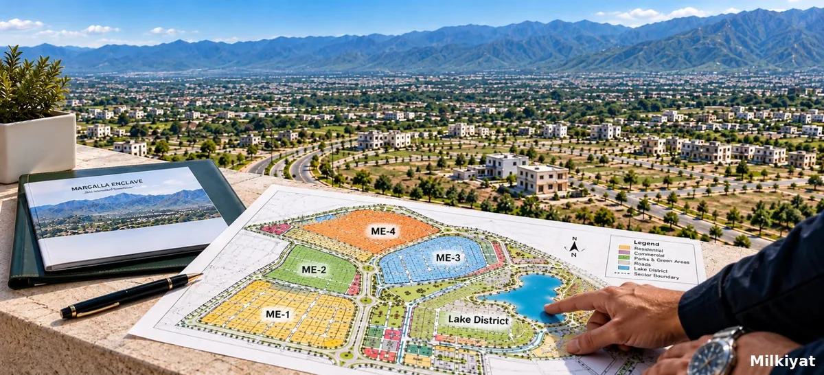
Start with the information that establishes the drawing’s context, then move towards the specific plot. This reduces the risk of matching a property to the wrong block or relying on a road or feature that is only planned.
- Check the title and date. Note the issuing body, version and approval reference; an untraceable file is only an informal visual aid.
- Read the legend. Use its key for residential, commercial, road and amenity symbols.
- Find the north arrow and scale. Without these, avoid precise measurement.
- Locate the sector or block. Check the plan’s own labels for ME-1 to ME-4 and Lake District.
- Trace the street. Use named roads and stable reference points, not just coloured shapes in a screenshot.
- Match the plot reference. Confirm whether the approved drawing actually shows individual plot numbers.
- Compare with the site. A visit can show visible conditions but cannot replace official records or a formal survey.
3. What the map can—and cannot—tell you
A layout plan may show roads, blocks, plot shapes, dimensions, land-use zones and planned public spaces. Its contents depend on the version, and it does not automatically show current site conditions.
| Detail on a map | What to check separately |
|---|---|
| Sector or block label | Whether the label matches the relevant allotment or transfer documents |
| Street or road | Whether the road is accessible and in what condition today |
| Plot outline or dimensions | Whether the official record for the specific plot confirms the same measurements |
| Park, lake or green area | Whether the feature is planned, under development or already completed |
| Commercial or residential zoning | Whether the official land-use designation permits the intended use |
| Corner, boulevard or park-facing position | Whether the plot’s recorded category and actual position support the claim |
For road access, use the Margalla Enclave location and access roads guide, and verify whether a route is open today. Likewise, a Lake District label does not prove that a plot is waterfront or that a planned amenity is operational. Confirm the land-use designation and present site conditions before paying a premium.
4. Plot numbers, sector labels and documents
Check whether the plot number on the seller’s documents can be matched to the map. Some marketing material says a layout shows blocks, streets and dimensions but not individual plot numbers. If sources conflict, do not guess: ask the responsible office whether the current approved plan identifies individual plots, and keep a dated record of its answer.
Online material has also used different sector descriptions for Margalla Enclave. Do not rely on a sector name copied into an advertisement; match the plot reference to official documents. For background on differing labels, see the guide to the Margalla Enclave C-14 location confusion.
Before paying, check the applicable allotment, intimation or transfer documents; the seller’s identity and authority to transfer; a payment statement showing paid amounts and outstanding dues; and written confirmation of transfer eligibility, category, dimensions and possession status. A map cannot establish ownership or prove that a seller is authorised to transfer a property.
5. How to check whether a map is to scale
A scale check needs a reliable scale or confirmed dimensions. A downloaded image or printout may have been resized or stretched.
If the official plan provides a scale bar, measure it with a ruler and compare the result with the distance stated on the bar. If the plan includes a known plot dimension, measure that feature and compare it with the stated dimension. Use multiple references where possible; one matching measurement does not prove the drawing is undistorted.
For example, if a confirmed 90-foot side measures 18 millimetres on a printout, the implied ratio is 5 feet per millimetre. A confirmed 50-foot frontage should then measure approximately 10 millimetres on the same printout. If the second reference differs significantly, check whether the plan was stretched, whether you measured the correct edge, or whether the assumed dimensions belong to a different plot type.
This is only a consistency check, not a survey; do not use it to mark boundaries or settle a dispute. For plot-size figures and area calculations, see the separate Margalla Enclave plot sizes and dimensions guide.
6. Use the map to compare listings—not to decide alone
Use the map as one part of a wider comparison. Similar-sized plots may differ in payment stage, unpaid instalments, transfer costs, location category and readiness. For each shortlisted property, record the plot reference, map version, documents, total asking price, outstanding payments and written possession status. Verify any corner, boulevard or park-facing premium against the relevant record; a visual impression is not enough.
Use the Margalla Enclave plot price tracker to compare ballot prices with resale asking prices. Confirm the payment basis and remaining obligations before comparing quotes. For alternatives, browse Islamabad property listings or houses for sale in Islamabad.
7. A practical verification workflow
Create one record for each shortlisted plot instead of relying on separate messages and screenshots. Save the full map file with its source and date, then note the block, street and plot reference exactly as they appear in the seller’s documents. Ask the relevant office to clarify any mismatch in writing. Keep the response with the documents so that the person reviewing the transaction can see which version and plot reference were checked.
Next, arrange a site visit with the seller or an authorised representative. Use it to compare access, visible surroundings and the claimed street position with the map. A site visit is not formal demarcation, and visible boundary markers may not establish the legal plot limits. If the exact boundary is important, ask whether an official demarcation or qualified survey is required.
Finally, separate map questions from transaction questions. The map may help you understand the layout; official records and transaction documents must establish identity, transfer eligibility, dues and possession. If any of these remain unresolved, pause the transaction rather than treating a matching map image as a substitute for confirmation.
Frequently asked questions
Which map should I use to verify a plot?
Request the current applicable layout from the responsible official office and confirm its date and status. A marketing image is useful for orientation only unless its source and approval can be verified.
Does a map prove ownership or possession?
No. Verify the plot reference through the relevant allotment or transfer records, and confirm possession and dues separately. Use formal demarcation or a qualified survey when exact boundaries matter.
Final checklist before relying on a plot map
Confirm the map’s source and date, match the plot reference to documents, check site conditions, and verify land use, possession and dues separately. If a key detail is unclear, seek written clarification before proceeding.
Disclaimer: This guide is for general informational purposes only. Maps, listings and marketing material may be incomplete or outdated. Independently verify plot identity, ownership, approvals, transfer eligibility, dimensions, possession, dues and other requirements with the relevant authorities and qualified professionals before making a property decision.